
The Quiet Legacy of Elkinton Millpond: A Deep Run Cornerstone
Introduction: The Echoes of Deep Run
Tucked away in the quiet, agricultural expanses of Alloway Township, Elkinton Millpond (historically referred to as Elkinton Pond) serves as a peaceful sentinel of Salem County’s evolving relationship with its natural waterways. Sitting at an elevation of approximately 13 feet (4 meters) above sea level, this 15-acre reservoir operates as a critical hydrological bottleneck within the historic Deep Run system. To the passing traveler commuting along the rural roads of Salem County, it appears as a tranquil stretch of still water reflecting the South Jersey sky. Yet beneath its glassy surface lies a narrative tightly bound to early American industry, local tribal memory, and 21st-century transition into the regional public utility network.
While many of Salem County’s recreational lakes boast sandy beaches and public docks, Elkinton Millpond has long maintained a more rugged, utilitarian character. It is a place where nature has quietly reclaimed the edges of human engineering, creating a rich micro-habitat where local history remains etched into the landscape.
Indigenous Roots and Naming Heritage
To fully understand the land surrounding Elkinton Millpond, one must look back to the original stewards of the region. Salem County itself derives its name from the Hebrew word for peace (Shalom), reflecting the Quaker ideals of its early European settlers. However, the ground beneath Alloway Township carries a much older legacy. The township is named in honor of Chief Alloway, a distinguished leader of the indigenous Lenni-Lenape people who inhabited these fertile hunting and fishing grounds long before colonial dams altered the flow of the creeks.
Historical accounts show that the camp of Chief Alloway’s village sat just a short distance northwest of the waterway network, and relics from the Lenni-Lenape era have been uncovered throughout the surrounding woodlands for generations. The pond today serves as a legacy of that peaceful wilderness, retaining its natural charm despite centuries of modern development.
An Industrial Legacy: The Milling Roots of Deep Run
The geographical backbone of Elkinton Millpond is the Deep Run waterway. Originating from natural springs further inland, the Deep Run winds its way through a series of historic millponds—including Cobb’s Mill Lake, Hazelhurst Pond, and Houses Pond (what’s left of it…. if anything)—before flowing directly into Elkinton Millpond. From there, the water pushes westward through the western end of Alloway into the broader Alloway Creek system.
During the 18th and 19th centuries, this specific waterway was the primary driver of Alloway’s commercial success. The steady, reliable flow of Deep Run allowed early settlers to establish an interconnected network of gristmills, sawmills, and fulling mills. Elkinton Millpond was originally dammed during this era to capture water power, operating as a vital holding basin that regulated the flow required to turn heavy mill wheels downstream. The pond effectively served as the community’s economic engine, transitioning Alloway from a remote agricultural outpost into a bustling hub of early American trade.
Geographic & Hydrological Profile
- Location: Alloway Township and Quinton Township border region, Salem County, New Jersey.
- Exact Coordinates: 39°32′45.5″N, 75°21′33.8″W (or 39.5501°N, 75.3718°W).
- Approximate Elevation: 13 feet (4 meters).
- Waterbody Type: Shallow freshwater reservoir / millpond.
- Primary Water Source: Fed directly by the Deep Run waterway.
- Downstream Discharge: Flows into the western reach of Alloway Creek.
The pond’s layout is long and narrow, functioning as a natural wetland buffer that helps attenuate seasonal floodwaters from the agricultural headwaters of Pilesgrove and Alloway. The lake bed features a soft, silty bottom rich in organic matter, a signature characteristic of South Jersey’s inner coastal plain waterbodies.
A Haven for Local Wildlife and Anglers
The Riparian Ecosystem
Because large portions of Elkinton Millpond have been protected from major residential development due to its status as a utility buffer, the surrounding landscape has matured into a thriving riparian sanctuary. The north and south banks are dominated by a dense canopy of mature deciduous hardwoods, sweetgums, and red maples.
This undisturbed cover makes it a haven for birdwatchers. Great Blue Herons are a frequent sight, standing like statues in the shallow, reedy coves as they hunt for frogs and small baitfish. Raptors, including local ospreys and passing bald eagles, utilize the high tree canopy to scan the open water. On sunny logs near the shoreline, dozens of painted turtles can be seen stacked together, soaking in the midday warmth.
The Angler’s Perspective
For the local angler, Elkinton Millpond is affectionately known as an “always catch something” pond. Despite its modest size and utility boundaries, it holds a surprisingly robust warmwater biomass. According to local angling logs and regional fishing databases, the most popular and common species targeted here include:
- Largemouth Bass (Micropterus salmoides) – The pond’s primary apex predator, frequently caught around submerged logs and weed edges.
- Chain Pickerel (Esox niger) – Thriving in the cooler, weed-heavy pockets of the pond.
- Black Crappie (Pomoxis nigromaculatus) – Abundant in the deeper pools near the old infrastructure.
- Yellow Perch & Pumpkinseed Hybrids – Providing excellent action for bank anglers utilizing light tackle.
Modernizing the Flow: The 2024 Public Utility Transition
In the mid-20th century, Elkinton Millpond transitioned from its historic milling roots into a critical asset for municipal infrastructure. The City of Salem acquired the pond, constructing a dedicated surface water intake at the site alongside the historic Elkinton Pond Pumping Station. Together with Laurel Lake, Elkinton Pond became a primary source of raw surface water, which was piped directly to Salem’s common water treatment plant on Grieves Parkway to supply thousands of residents.
However, maintaining aging infrastructure posed a severe challenge for the municipality. The water system’s infrastructure spanned an incredible age range, with some components dating back to 1880. On April 21, 2023, the New Jersey Department of Environmental Protection (NJDEP) issued an Emergent Condition Certification under the Water Infrastructure Protection Act. The state concluded that the system suffered from a “demonstrated lack of historical investment, repair, or sustainable maintenance” and that the city lacked the financial and managerial capacity to operate it sustainably, with the utility running at a negative cash flow.
To safeguard the region’s water security, the City of Salem put the system up for public bid. Following a successful voter referendum on November 7, 2023, a $18,000,000 purchase agreement was executed to sell the water and wastewater assets to the New Jersey American Water Company (NJAWC).
Because the transfer involved lands used to protect a public water supply, it fell under the strict moratorium of the Watershed Protection and Moratorium Act. On May 1, 2024, the New Jersey Watershed Property Review Board officially signed an order granting a full exemption for the sale. This landmark decision transferred ownership of the Elkinton Mill Pond parcels (including Block 1701, Lot 61 and the Quinton-side dam structures) to NJAWC. This transition has kicked off a massive, multi-million dollar capital improvement plan intended to modernize the Elkinton Pond Dam (NID ID: NJ00102) and its pumping facilities, ensuring the structural integrity of the watershed for generations to come.
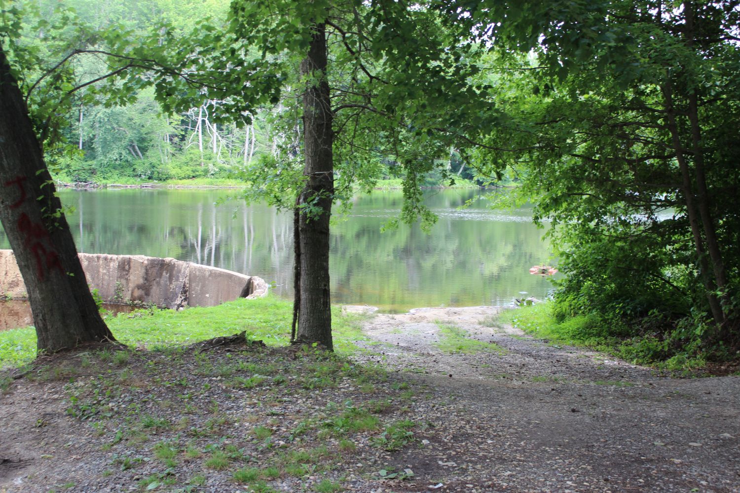
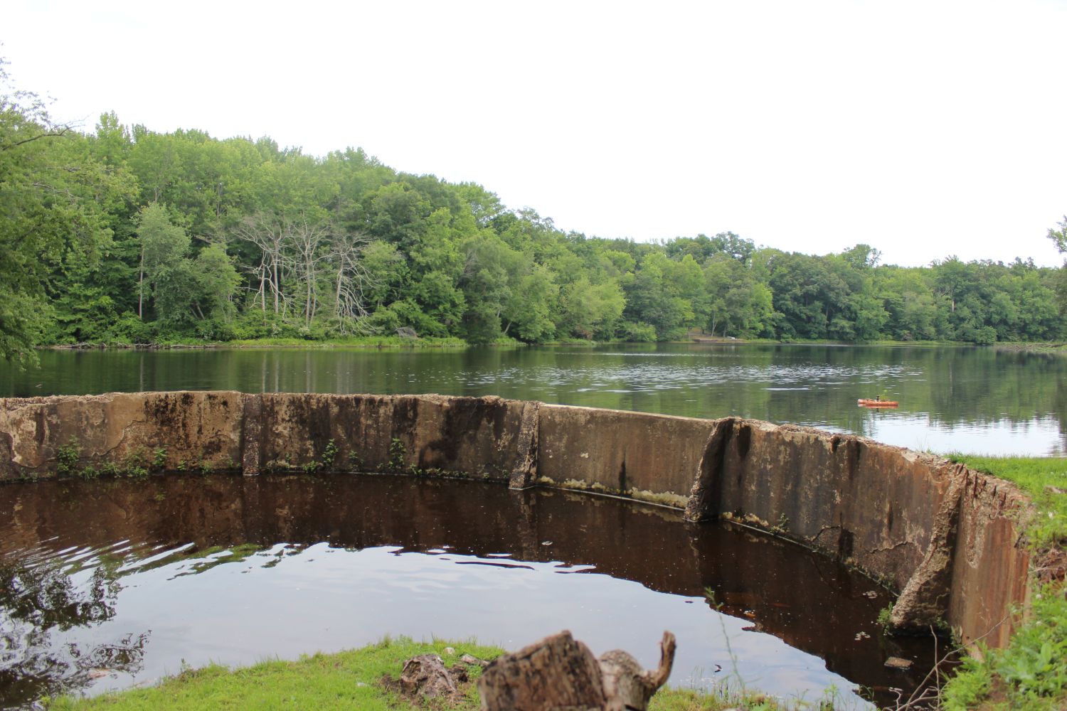
The Unimproved Hand-Launch Path: Framed by mature deciduous trees, a gravel-and-dirt access path leads directly down to the water’s edge, serving as a primitive launch site for local kayakers. On the left, the sweeping concrete wall of the dam sits high above the current waterline, providing clear visual evidence of how much the pond’s depth has naturally receded over the last few decades.
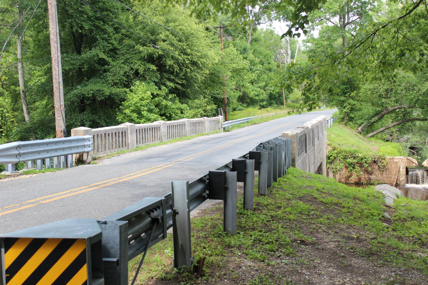
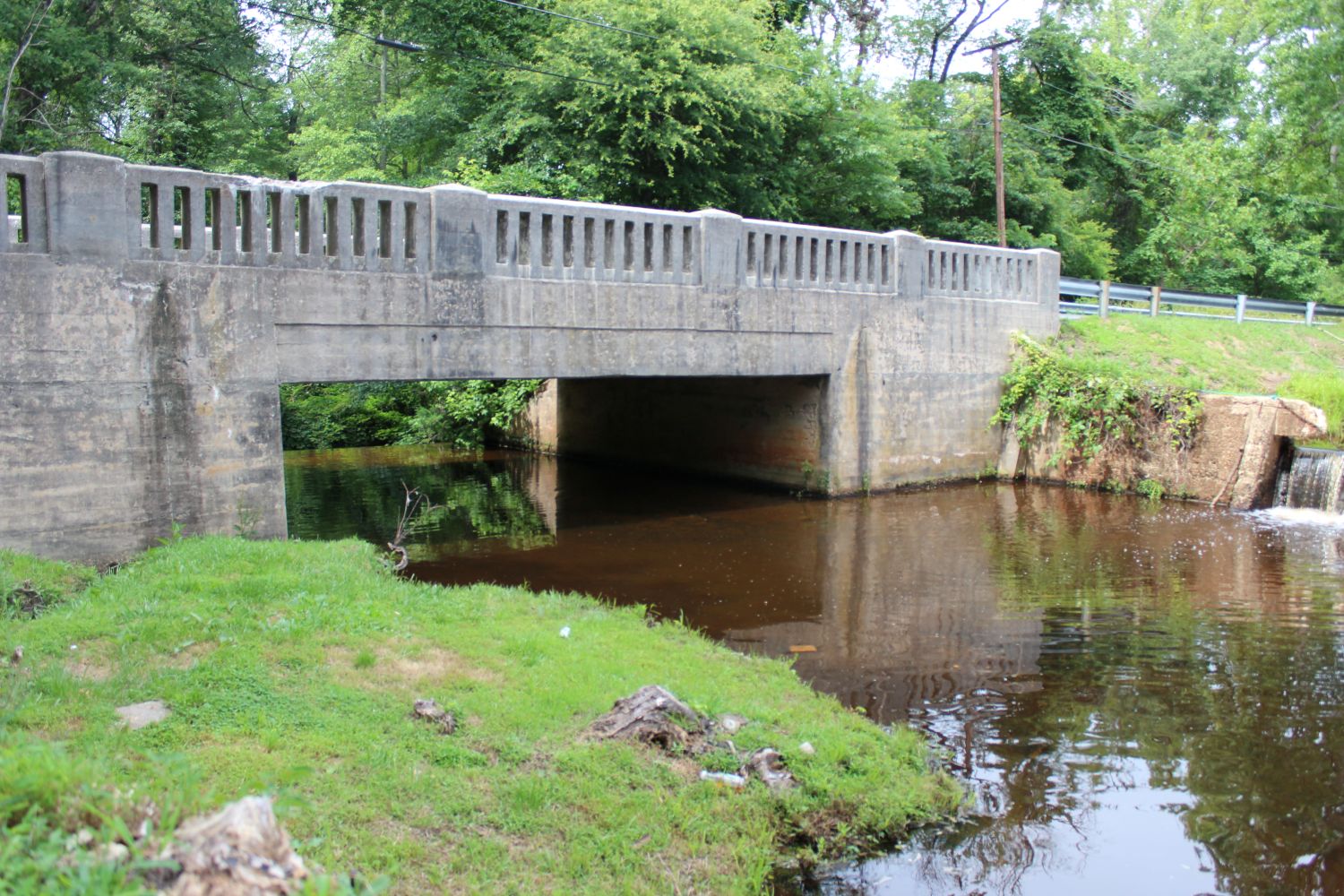
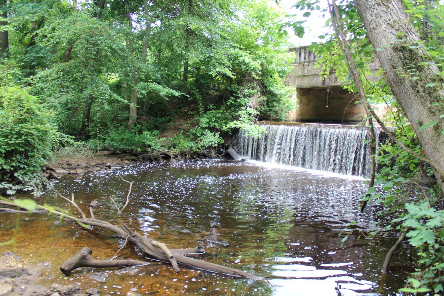
The Hidden Cascade: Tucked away beneath a thick canopy of trees behind the main road bridge is a beautiful concrete drop-spillway. Here, the still reservoir water transforms into a lively, highly oxygenated waterfall, tumbling into a rocky plunge pool before continuing its journey down the Deep Run toward Alloway Creek.
Visitor Notes & Pro-Tips
Access Notice: Elkinton Millpond is primarily a utility-restricted site and does not feature formal park amenities such as public restrooms, picnic tables, or paved walkways. Visitors must respect all posted “No Trespassing” signs near the active pumping station, dam structures, and spillway. Be careful when around the road as it is a very unsafe area with no shoulders.
Paddling the Pond: There is no formal concrete boat ramp. However, the pond is popular for small, hand-carried watercraft like kayaks and canoes. Accessing the water from public rights-of-way requires caution, and utilizing a small paddle craft is highly recommended to properly fish the tight, weed-heavy pockets along the heavily wooded far banks. The water level is very low so please take this into consideration.
Gear Up: If you plan on exploring the bank areas or legal fishing spots near the road overpasses, a solid pair of waterproof muck boots is your best friend. The clay-heavy South Jersey mud can be deep, and the banks are often slick and thick with briars.
License Regulations: As with all state-managed and public utility waters in New Jersey, a valid NJ State Fishing License is strictly required for anyone between the ages of 16 and 69.